Strava news and tips

-
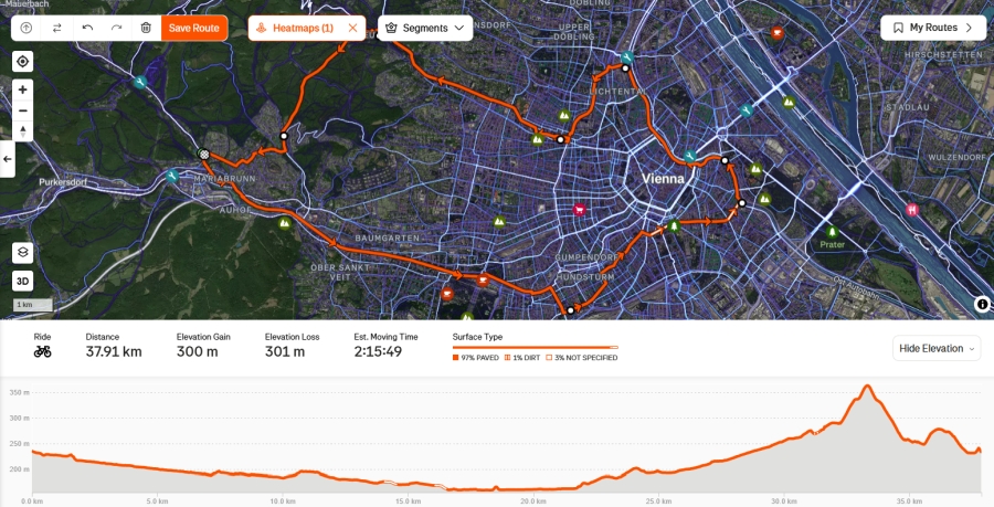
Strava Route Builder – My Go To Tool for Planning Cycling Routes
I’ve been using Strava Premium for a while now, and one of the features I rely on the most is the Strava Route Builder. It has become an essential tool whenever I want to explore new areas or even...
-

What is Strava?
Strava is a popular fitness tracking and social networking platform primarily used by runners, cyclists, and other outdoor enthusiasts. It allows users to record their workouts via GPS, track their...
-

Every 19 Seconds: Compete
Sometimes our biggest challenge is feeling like ourself again. No matter your goal, Strava helps you challenge yourself, and each other Challenge yourself with the Subscription...
-

Every 19 Seconds: Explore
When everything’s new, running can feel like home???? Starting fresh in a new city or job? Strava helps you find your routes, your rhythm and your people. Explore with the Strava subscription: https://strava.app.link/subscribe-yt
-
Every 19 Seconds: Train
Ever struggled to call yourself a “runner”? Here’s a secret: If you’ve gone for a run, you are one ???????? Whatever your goal – big, small, fast or slow – the Strava Subscription can help you train for it. Learn more here: https://strava.app.link/subscribe-yt
-

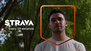
Every 19 Seconds
Every 19 seconds on Strava, a subscriber hits a goal. This film is about the chase – the early mornings, the little wins, the friends who get it. It’s about doing the stuff that makes us feel alive out there ♀️ ♂️ So whatever your goal is – a faster PR, a new habit – ...
-
Strava Metro - Data that Serves #strava #stravametro #earthday #cycling #running #hiking
This Day, we interrupt your regularly scheduled scroll to spill the tea on Strava Metro. Reminder: Tagging your commute on Strava = real-world change. ♀️ Sidewalks, bike lanes, trails... they don't build themselves. So help Mother Earth out by tagging your...
-

It’s official: Strava ➕ Runna are joining forces
Strava is more than tracking workouts – it’s where over 150 million athletes in 185 countries make progress together, from building new habits to achieving new personal bests. And now that Runna is joining the world’s biggest team, we’ve got even more ways to help our active community reach ...
-

-

Routes you can filter? Groundbreaking.
Thanks to one brave employee, you can now filter your saved Routes by length, elevation, difficulty and more :world_map: #strava #stravacycling #stravarun #stravarunning #cycling #cycle #cyclist #cyclinglife #runner #running #run #hiking #hike #route #routes #cyclingroute
-

Cars don't belong on segment leaderboards.
Our improved machine learning model helps detect and remove cars on segments - so your efforts get the recognition they deserve. ???? ???? Learn more: strava.com/clubs/231407/posts/35627034 #Strava #KOM #QOM #SegmentHunting #stravaleaderboards #stravasegment
-

How to use Strava's New Winter Map Layers
Before you drop in, check what’s under your skis! Strava’s new Winter Map Layers – Aspect, Gradient and Avalanche Gradient – help you chase fresh pow, avoid sketchy slopes and plan safer winter adventures ⛷️️ Marcea’s here to show you how she’s using them to stay safe and...
-

My mind while running: ✨☄️
My mind while running: ✨????????????????????☄️???????????? #running #run #runner #strava #stravarun #stravarunning #runningmotivation
-

Share 3D videos of your epic and everyday Strava activities on social
Go ahead. Make people jealous. :nail_care: Subscribers can now share their epic moments with Flyover’s 3D videos directly to Instagram, Facebook, WhatsApp, or Messages. No screen recordings needed. Learn more here https://www.strava.com/clubs/231407/posts/35636844
-

Join the world’s biggest team
Got a goal? Don’t chase it alone. Go after it with 135 million teammates!
-

Join the world’s biggest team
Got a goal? Don’t chase it alone. Go after it with 135 million teammates!
-

Join the world’s biggest team
Got a goal? Don’t chase it alone. Go after it with 135 million teammates!
-

Join the world’s biggest team
Got a goal? Don’t chase it alone. Go after it with 135 million teammates!
-

Your goals start here
Every 19 seconds, someone on Strava hits a goal. Start chasing yours today with the world’s biggest team!
-

Play. Explore. Move.
The planet was our playground this year. Where will you explore with Strava?
-

Tobin Heath & Demi Vollering Talk Women's Sports
An interview with two-time Olympic gold medalist, two-time FIFA World Cup Champion, and U.S. Women’s National Soccer Team member Tobin Heath and 2023 Tour de France Femmes Winner Demi Vollering. Tobin Heath sits down with Demi Vollering ahead of this year's Tour de France Femmes avec Zwift to...
-

How hard is the Tour de France Femmes avec Zwift?
92% of the women's pro peloton are on Strava, uploading their rides, taking QOMs, counting kudos, and thinking up witty titles like the rest of us. So even if you're not at the Tour, you can follow your favorite riders and give them kudos. It's the next best thing to cheering them on in...
-

How do you win the Tour de France Femmes avec Zwift?
How do you win the Tour de France Femmes avec Zwift? In multi-day stage races like the Tour de France Femmes, it's not just about who crosses the finish line first – there are multiple ways to win and each colorful jersey represents a different leading category Follow the tour...
-

What are the different rider roles in the Tour de France Femmes avec Zwift?
Just like soccer or basketball, cycling is a team sport. In the Tour de France Femmes avec Zwift, there are 22 teams with about 7 riders each. They ride in a peloton to reduce drag, each playing a unique role: leaders, climbers, sprinters and domestiques. Superstars like Demi Vollering and Alison...
-

Why should you watch the Tour de France Femmes avec Zwift?
Did you know there’s still a huge gap in viewership between the men’s and women’s Tour de France? The difference is mainly due to less media coverage and lack of options to watch the full tour on TV and streaming platforms. This leads to smaller prize money, fewer sponsorships and fewer...
-

What is the Tour de France Femmes avec Zwift?
♀️ The fastest women in the world are gearing up for glory at the Tour de France Femmes avec Zwift. Grueling climbs, surprise attacks, dramatic finishes – it’s all on the line. With the help of our host, Jenna Marie Foley, we’re covering everything you need to know ahead of...
-

Dark Mode is Here, Finally.
It’s been 84 years, but the wait is finally over: dark mode is now on Strava. Thanks for hanging in there ???? The feature is free and available to everyone starting today. Learn more here: https://support.strava.com/hc/en-us/articles/27117698066317-Dark-Mode-on-Strava
-

Camp Strava 2024: Fireside Chat: Progress Together
What motivates and inspires people and communities to move, explore, and connect—not just to chase, but to reach their goals? How does this shift across sports and lived experiences, and what role can technology play? This conversation brings together two incredible thought leaders in sports and...
-
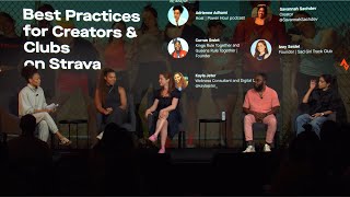
Camp Strava 2024: Best Practices for Creators & Clubs on Strava
Hear from some of Strava's leading creators and club organizers as they share practical advice for growing your following and engaging your community on Strava. Moderator - Adrienne Adhami | Host, Power Hour podcast Savannah Sachdev | Creator, @SavannahSachdev Curran Swint | Founder, Kings Rule...
-

Camp Strava 2024: Motivation Has Entered the Chat: Device-Powered Inspo and Where to Find It
Devices have powered our movement for decades, from the heyday of the 10,000-step count to the future of AI-generated training and coaching. What have we collectively learned, and how can it move us forward? Moderator - Des Yap | Founder, DesFit Kelly Hancox | Sr. Director of Global Partnerships,...
-

Camp Strava Keynote 2024
Camp Strava is an annual event gathering incredible athletes, explorers, community builders, event organizers and world-class brands that drive movement across the globe. Tune in to hear more about the future of Strava and product releases you can look forward to in the coming year.
-

Camp Strava 2024: She’s Got Game: Trailblazing Women in Sport
Women’s sports is a movement not a moment. The women’s basketball tourney far outpaced the men in TV viewership, and we’ve entered what some are calling a golden era of female sports superstars. And while it seems official that Everyone Watches Women’s Sports, it’s about more than...
-

Giro d'Italia Strava Segment - Monte Grappa
The final mountain battle of Giro d'Italia 2024 takes place during stage 20. Riders will tackle the legendary Monte Grappa – an iconic climb that's made history in every edition of the Giro. This year, they'll attack from two different aspects. Which team jersey will conquer the endless...
-

Camp Strava 2024 LIVE
New product features are being announced at Camp Strava, and we want YOU to be the first to know about them. Camp Strava is an annual event gathering incredible athletes, explorers, community builders, event organizers and world-class brands that drive movement across the globe. On Thursday, May ...
-

Did someone say... Dark mode?
It’s been 84 years, but the wait is finally over: dark mode is now on Strava. Thanks for hanging in there
-

Rest & Recovery feat. Erin Bailey
Erin Bailey knows rest and recovery are non-negotiables as she maps her route to the London Marathon. Off days and prioritizing quality sleep keep her ready to tackle even the most intimidating training sessions. Learn more ...
-

Training & Mindfulness feat. Arby Abrahan
According to Arby Abrahan, greatness requires mindfulness. Extra efforts like breathwork and meditation are key as she balances life as an entrepreneur and marathon training. Learn more: https://stories.strava.com/articles/a-new-way-to-celebrate-your-extra-efforts
-

Training & Mindfulness feat. Arby Abrahan
According to Arby Abrahan greatness requires mindfulness. Extra efforts like breathwork and meditation are key as she balances life as an entrepreneur and marathon training. Learn more: https://stories.strava.com/articles/a-new-way-to-celebrate-your-extra-efforts
-

The Makings of Greatness
Strava, Open and ŌURA have teamed up to help you track your activation, stretching, self-care and recovery habits alongside the activities they help you prepare for. Join The Makings of Greatness Challenge today to celebrate all the extra efforts you make. Because greatness is built, not born....
-

The Makings of Greatness
Greatness is built, not born. See all your extra efforts in one place – on Strava. https://strava.app.link/the-makings-of-greatness
-

Share the Full Picture of Your Training
Keep track of your prep and recovery. Now, you can upload a more complete picture of your workouts by adding ŌURA + Open info to any activity. Just connect the Open mindfulness app or your Oura Ring to Strava to see the breath work, rest and recovery efforts that play a key role in your training. ...
-

When We Strava - Competitive Dad
When We Strava - Competitive Dad. Chase your personal best with Strava. It's easy and free to join.
-

When We Strava - Chams
Share your workout pics, videos and more on Strava. It's free to join.
-

When We Strava - Dog Walker
Walk, run, ride and more – record it all here. Download the #1 app for active people and join for free.
-

When We Strava - Trail Tummy
Never miss a turn (or rest stop) with the world's largest trail and route resource. Get the #1 app for active people today.
-

Camp Strava 2023: The Creator Economy & the Business of Being Active
We’ll hear how a range of athletes and creatives have built a brand on the foundation of being active and leveraged their presence on Strava to both grow and authentically engage their audiences.
-

Camp Strava 2023: Architecting the Active Community of Tomorrow
In a post-pandemic world, the ways that thriving active communities form has become increasingly fragmented, yet human beings hunger more than ever for meaningful interaction, online and in real life. Podcaster Rich Roll will lead a thoughtful discussion about the future of how communities will...
-

Camp Strava 2023: Rewiring Cities: Building for People, Not Cars
Thought leaders and advocates from the urban and transportation planning world share insights on how active travel and recreation trends can impact the future of our communities.
-

Camp Strava 2023: It Takes More than a Pair of Shoes Unlocking Equitable Access to Movement
Debunking the myth that “all you need is a pair of shoes!” to get active. We’ll hear from people in marginalized communities about just how much more it takes to feel a sense of belonging, safety, and community—and what each of us can do to help meet those needs.
-

Camp Strava 2023: The Future of Human Powered Exploration
The co-founder of the world's foremost mapping tool for exploration, Misha Gopaul, will be in conversation with the mountain athletes who are charting the course for a new era of exploration. They'll discuss what it means to adventure without limits, while still mindfully considering the...
-

Camp Strava 2023: Community on Strava: Connecting Digital to IRL
In this hands-on session, members of the top clubs on Strava—including event organizers, community groups and brands—share their tips & tricks for building an audience and engaging them on-platform and IRL.
-

Camp Strava 2023: Welcome + Opening Keynote
Hear from Strava co-founder and CEO Michael Horvath, key company leaders and special guests to kick off Camp Strava!
-

-

Strive for More
After a generation, Le Tour de France Femmes avec Zwift is back. It’s going to be the race of a lifetime. It’s also a much needed step toward a world where sport can thrive and every person who wants to take part can do so without discrimination and barriers. That's why we’re committed to...
-

The Roseiras Climb ft. Vicky and Eloïse
Finding uninterrupted riding in a metropolitan area of over 22 million people might take a short drive, but thankfully, there are plenty of cyclists in Brazil happy to join you. Follow along with Vicky and Eloïse of São Paulo's Fuga Cycling Club as they tackle the Roseiras climb and show what...
-

Morning Commute with Chris Burkard
As a photographer and adventurer, Chris Burkard has ridden his bike from the coasts of Iceland to the mountains of South America. But of all the enviable landscapes he’s explored, his favorite ride is his daily commute. “If I'm able to jump on my bike and commute, my whole day is better. And I ...
-

The Schuylkill River Trail with Richard Issa Bockari
Sometimes segments aren’t about the leaderboard or chasing a PR. Sometimes they’re about the ritual, and the reward that comes from running together. Let’s hit the Schuylkill River Trail, or SRT as it’s known to members of the Issa Run Crew, and find out what keeps them coming back week...
-
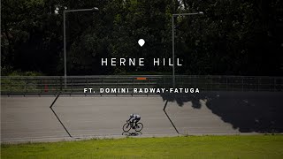
Herne Hill Velodrome with Domini Radway-Fatuga
London’s Herne Hill Velodrome was built in 1891, three years after the invention of the pneumatic bicycle tire. And it isn’t just significant to cycling history, it’s a part of history-history. The track was the site of a gun battery in the second world war, hosted the 1948 Olympics and has...
-
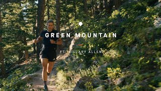
Green Mountain with Hillary Allen
The Green Mountain Trail is iconic in the Boulder, Colorado community and it has special meaning for Hillary Allen. It’s where she got into trail running. And it’s where she relearned to run after a 150 foot fall broke bones in her legs and back. But while she was training to Everest the...
-

The Legend of Mount Azuma with Ryoma Minegishi
Running has long been measured in distance and time. Enter skyrunning – a relatively new discipline that’s focused on elevation. It’s running, but not as you might know it. Ryoma Minegishi is a skyrunner. A Local Legend of a segment moments from his home in Kiryu, Japan, the time-crunched...
-

Running Is for Every Body
Growing up, Chardline Chanel didn’t see any runners who looked like her. Now she has set out to change that.
-

Staying Alive
Once, Mikito Fujimoto was running away from his fears. Now he's running (and riding) for the best prize of all: his life.
-

Failure Is Not an Option
Alex Roca lives with cerebral palsy but refuses to let it define his limits.
-

Finding New Frontiers Through Sport
In a couple years, Sophia Lattimore went from learning to shift gears on a bike to competing in triathlons.
-

Making Progress, One Day at a Time
After her mother died of cancer, Mariana Balestra began making small changes to improve her health day by day. Now she has her sights set on a 100 km race.
-

Building Community Through Movement
Running helped Tazneem Anwar discover herself and her city. Now she is connecting other women to running and to one another. Commit to the athlete in you: https://www.strava.com/the-athlete-in-you
-

Front Lines and Starting Lines
René Najera was worked to the edge by the pandemic – here’s why he still exercised every day.
-

The Athlete In You
There’s an athlete in all of us. And when you give it a chance to let loose, you might be surprised what you can do. Find out: https://www.strava.com/the-athlete-in-you Produced by Creative Theory Agency
-

Strava Segment Stories: Grand Col Ferret (UTMB® Mont-Blanc)
Segments tell the stories of the communities who built them. Some carry the indelible memories of the elite pros, others the tales of wide-eyed amateurs – moments that later fade into myth, into legend. The Grand Col Ferret is one of those. It’s housed the greatest trail running battles in the ...
-

PRJCT RUN
PRJCT RUN was built to empower Black athletes and provide the representation in the running community that founder Debora Taylor had been looking for and failing to find. To nail their monthlong Group Challenge, PRJCT RUN members leaned into the momentum of motivating and being motivated by...
